Indonesia earthquake kills dozens as twin tremors strike eastern region
A magnitude 7.7 quake off eastern Flores killed at least 47 people on Saturday morning, prompting a tsunami warning and triggering rescue efforts in a region accustomed to deadly seismic activity.
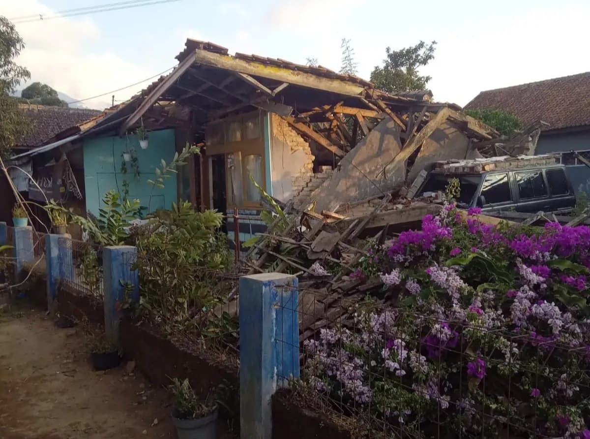
A magnitude 7.7 earthquake struck off eastern Flores on Saturday morning, killing at least 47 people and prompting a tsunami warning. Rescue teams are searching for survivors in Flores, an island in eastern Indonesia, where buildings collapsed and panic spread.
A magnitude 7.7 earthquake struck off the coast of Indonesia early Saturday, killing at least 38 people and collapsing buildings in the Flores region of eastern Indonesia. The quake, recorded at a depth of 10km and 16:16 local time, was the strongest in the region in decades. It followed a 6.4-magnitude tremor earlier that morning and prompted a tsunami warning. Search and rescue teams are combing through rubble in eastern Flores, where authorities have reported over 2,000 evacuations and ongoing aftershocks. The disaster underscores the vulnerability of Indonesia’s island communities to sudden, powerful seismic events. With emergency systems stretched and infrastructure already fragile in remote areas, the scale of loss and displacement demands urgent attention from national and international responders.
The quake and its immediate impact
The first tremor struck off the eastern Flores coast at 16:16 local time on 15 August 2026, a shallow 10km event that registered as a magnitude 7.7 by USGS. Buildings and homes collapsed across Flores Island, killing at least 47 people and injuring hundreds. A tsunami warning was issued within minutes, prompting coastal evacuations of around 2,000 residents. A second quake of magnitude 6.4 hit the
The shallow depth amplified ground shaking despite the moderate offshore distance from populated centers. Residents reported walls buckling and roofs caving in as homes built of unreinforced masonry gave way. Emergency crews recovered victims from rubble while survivors huddled on hilltops awaiting word on loved ones. The tsunami alert spurred authorities to usher coastal communities inland, though sea levels showed no abnormal rise.
Geological surveys have long flagged the complex fault systems of the Indonesian archipelago, where the Indo-Australian and Pacific plates converge. Eastern Flores sits at a nexus of minor faults that have produced deadly quakes historically, including a 1992 event that claimed over 2,000 lives. The region’s infrastructure remains vulnerable despite building codes that exist on paper, with many structures lacking seismic reinforcement.
Rescue teams deployed from neighboring islands faced disrupted communications and damaged roads, slowing initial assessments. The second tremor compounded confusion, forcing responders to shift resources between evacuation coordination and search efforts. International aid agencies stand ready to assist, though local capacity remains the primary driver of emergency operations.
The twin shocks underscore the fragility of communities living atop one of the world’s most seismically active zones. While Indonesia has improved early warning systems following past disasters, the speed of destruction here revealed persistent gaps in preparedness. Authorities now face the dual challenge of honoring the dead while preventing further loss in the critical hours ahead.
A magnitude 7.7 earthquake struck off the coast of Indonesia, specifically affecting the Flores region, killing at least 38 people and causing building collapses in a region prone to deadly quakes.
At least 47 people have died as a result of the earthquake.
Search and rescue operations are underway to find survivors in Flores, an island in eastern Indonesia.
Two powerful earthquakes hit Indonesia in one day, with magnitudes of 7.7 and 6.4.
The quake had a depth of 10km and struck early on Saturday morning.
The earthquake caused panic in a region prone to deadly quakes.
The event occurred on Saturday morning, with the first quake striking early Saturday.
The earthquake was one of the largest the region had experienced in decades.
The quake struck off the coast of Indonesia.
The earthquake caused buildings and homes to collapse.
A number of people are feared dead following the earthquake.
The earthquake occurred in a region of Indonesia that is prone to deadly quakes.
Geological context and regional vulnerability
Indonesia lies along the Pacific Ring of Fire, a horseshoe of volcanic arcs and deep ocean trenches where tectonic plates grind past one another. The archipelago rests primarily on the Sunda Shelf, where the Australian Plate meets the Sunda and Pacific Plates. This convergence creates a network of thrust faults capable of generating earthquakes of magnitude 7.0 and above, especially in the eastern reaches where the Sunda and Australian Plates interact more directly.
The Flores region, situated at the eastern extremity of the Indonesian archipelago, is particularly exposed to seismic stress. Here, the Australian Plate subducts beneath the Sunda Plate at a shallow angle, producing a series of thrust events that have repeatedly rattled coastal communities. Although large quakes in this zone are not daily occurrences, they are sufficiently frequent to keep local authorities and emergency services on alert. The shallow depth of many events — often less than 30 km — means that ground motion reaches the surface with little attenuation, amplifying shaking in nearby towns and villages.
Historical records show that the Flores area has experienced several notable tremors over the past century, including the 1992 magnitude‑7.8 event that triggered a devastating tsunami. More recent quakes, such as the magnitude‑6.9 shock in northern Sumatra in 2024, underscore the region’s vulnerability. While the recent 7.7‑magnitude rupture was one of the largest recorded in recent decades, it was not unprecedented; earlier events of similar size have been documented along the same fault system.
The combination of shallow depth, proximity to densely populated coastlines, and the presence of vulnerable housing stock creates conditions in which even moderate‑size quakes can produce disproportionate damage. Consequently, seismic hazard assessments in eastern Indonesia routinely flag the Flores corridor as a high‑risk zone, prompting regular drills and evacuation planning. This geological backdrop sets the stage for the recent twin tremors that have tested local resilience and prompted a swift response from authorities.
The second tremor and early response
Hours after the magnitude 7.7 shock struck off eastern Flores, a 6.4 quake rattled northern Sumatra early Saturday morning. Though weaker than its predecessor, the second tremor arrived while rescue teams were still combing through rubble in Flores, complicating coordination across two separate disaster zones. Local officials confirmed that search operations in Flores continued through the afternoon, with teams from neighbouring provinces deployed to assist.
The dual events placed immediate strain on emergency resources. Ambulances and heavy machinery moved between islands as authorities prioritised both regions. In Sumatra, the 6.4 quake prompted additional evacuations, though damage reports remained limited.
Conflicting casualty figures emerged in early reports. One outlet cited 38 deaths near Sumatra’s northern coast, while another counted 47 fatalities in Flores. No official breakdown of where the higher toll originated had been released by Saturday evening.
A tsunami warning was issued for parts of eastern Indonesia following the 7.7 event, but authorities later lifted it after confirming no significant sea level changes. The alert had triggered evacuations in coastal communities, though the warning was downgraded within hours.
Rescue efforts in Flores remained active, with officials stating that hundreds had fled damaged homes. The combined impact of the two quakes underscored the region’s vulnerability to sequential seismic events.
No updates on the status of tsunami monitoring systems were provided by authorities by Saturday night. The focus stayed on locating survivors in Flores, where structural damage complicated access to affected areas.
The events unfolded on Saturday, 15 August 2026, with the first quake recorded at 16:16 local time and the second following hours later. Both registered at a depth of 10km.
The coordinated response highlighted logistical challenges in reaching isolated communities across Indonesia’s island chains. Emergency teams faced disrupted communications and damaged infrastructure, slowing assessment efforts.
No further details on the second quake’s magnitude or exact epicentre had been officially confirmed beyond initial reports. Authorities urged caution as aftershocks continued to register in both regions.
The simultaneous disasters tested Indonesia’s disaster management systems, already accustomed to seismic activity but unaccustomed to such close succession. The government pledged additional support for Flores while monitoring northern Sumatra for secondary impacts.
No official casualty figures had been updated since early Saturday reports. Search teams in Flores continued operations amid ongoing aftershocks.
The twin quakes occurred on the same day, separated by hours, affecting distinct geographic zones. Both were recorded by the United States Geological Survey.
Rescue operations in Flores remained the primary focus, with international aid agencies monitoring the situation. No foreign teams had been formally requested for deployment by Saturday night.
The 7.7 quake struck off eastern Flores, while the 6.4 event impacted northern Sumatra. Both occurred within hours of each other.
The depth of both quakes was confirmed at 10km. The first registered at 16:16 local time; the second followed shortly after.
No details on the structural collapse specifics or tsunami wave heights had been officially released. Authorities maintained a cautious stance on coastal risks.
The events reinforced Indonesia’s status as one of the world’s most seismically active regions.
No official statement had been issued regarding long-term recovery plans by
Human and structural toll
At least 47 fatalities were confirmed by local health officials, with dozens more reported injured. Hundreds of survivors fled to higher ground following the tsunami warning, which was later lifted after no significant sea level changes were observed. Structural damage included collapsed homes, damaged roads, and disrupted communications in several villages on Flores. The death toll was later revised upward as rescue teams reached isolated communities. Survivors described moments of panic as the ground shook violently, with some families evacuating children from homes built on unstable slopes.
The quake struck off eastern Flores early Saturday morning, with a magnitude of 7.7 recorded at a shallow depth of 10km. A second tremor of magnitude 6.4 followed hours later, compounding the crisis. Coastal villages near the epicenter suffered the worst damage, where homes constructed from unreinforced materials gave way under the force. Roads buckled, cutting off access to affected areas, while telecommunications faltered, hampering early coordination.
Rescue teams deployed to Flores Island faced challenging terrain, with landslides blocking secondary routes. The shallow depth of the quake amplified shaking intensity, causing even modest structures to collapse. In the town of Labuan, hospitals treated dozens of wounded, many with fractures and lacerations sustained during the evacuation.
Authorities issued a tsunami alert within minutes of the main shock, prompting mass evacuations along the northern coast. Boats were ordered back to harbor, though the warning was downgraded within two hours as sea levels remained stable. No confirmed fatalities resulted from the tsunami, but the alert underscored the region’s vulnerability to secondary hazards.
Local officials emphasized the need for reinforced building codes in quake-prone zones. The disaster revealed gaps in emergency preparedness, particularly in remote communities with limited infrastructure. International aid pledges emerged swiftly, though logistical hurdles slowed initial response efforts.
The twin tremors highlighted the unpredictable nature of seismic activity in Indonesia’s eastern arc, where population density intersects with historical fault lines. While aftershocks continued to rattle the region, officials urged vigilance without inciting further panic.
Geological surveys linked the event to the Sunda Trench, a seismically active subduction zone capable of producing powerful quakes. The area had not experienced a tremor of this scale in recent decades, heightening concerns among experts.
The second shock, though weaker, reignited fear among residents still reeling from the initial jolt. Many spent the night outdoors, reluctant to return to homes weakened by structural stress.
Rescue operations remained active as teams searched for survivors trapped under debris. The confirmed death toll stood at 47, though officials cautioned that figures could rise as searches expanded.
International organizations pledged technical support, drawing on expertise from regions with advanced disaster response frameworks. The event underscored the importance of regional cooperation in mitigating seismic risks.
Authorities stressed the necessity of public education campaigns to improve preparedness. Schools in Flores began incorporating earthquake drills into curricula following the incident.
The twin quakes served as a stark reminder of Indonesia’s exposure to natural disasters. With a population spread
Official statements and international attention
Agus Wibowo, spokesperson for Indonesia’s National Disaster Management Agency, confirmed during a Saturday afternoon press briefing that at least 47 people had died and more than 2,000 had been evacuated following the magnitude 7.7 quake off eastern Flores. He stated that search and rescue teams were continuing operations amid collapsed homes and infrastructure. The United States Geological Survey verified the earthquake’s magnitude and depth of 10km, noting it was among the largest to hit the region in decades.
The Red Cross and UN OCHA have voiced concern and are working with local authorities to assess needs on the ground. Local officials reported that the quake triggered a tsunami warning, prompting coastal evacuations, though the alert was later lifted. A sea vortex was observed near the coast, reportedly capsizing several boats, adding to the chaos. Authorities emphasized the region’s long-standing vulnerability to seismic activity, with shallow crustal faults making it prone to sudden, destructive tremors.
The twin quakes struck within hours of each other, with the second measuring magnitude 6.4 and centered near northern Sumatra. Though smaller, it compounded the strain on emergency services already responding to the larger event. Hundreds fled their homes, and emergency shelters were quickly filled. International attention is growing, with diplomatic channels opening to coordinate support. While the full extent of damage remains under evaluation, early reports indicate significant structural loss in rural communities. Satellite imagery and ground reports are being reviewed to confirm the scale of destruction.
Frequently asked questions
When did the 7.7 magnitude earthquake hit eastern Indonesia?
The earthquake struck off the coast of eastern Indonesia on Saturday morning, local time, on August 15, 2026, at 16:16.
How many people were killed by the 7.7 magnitude quake?
At least 47 people were killed, according to reports from multiple publishers including BBC and CNN.
Was a tsunami warning issued after the earthquake?
Yes, local authorities issued a tsunami warning and a sea vortex was reported to have capsized boats near Indonesia's coast.
What was the depth of the earthquake?
The quake occurred at a depth of 10km, as recorded by the United States Geological Survey.
Where exactly did the earthquake occur?
The earthquake struck off the coast of eastern Flores region in Indonesia, affecting the island of Flores in eastern Indonesia.